“The only true need anyone has is to be seen as real.” – Deepak Chopra
“The only true need anyone has is to be seen as real.” Deepak Chopra. The same can be said of archaeology and why it is good to see it in context instead of under glass. That is why I explore hidden history in the wilderness.
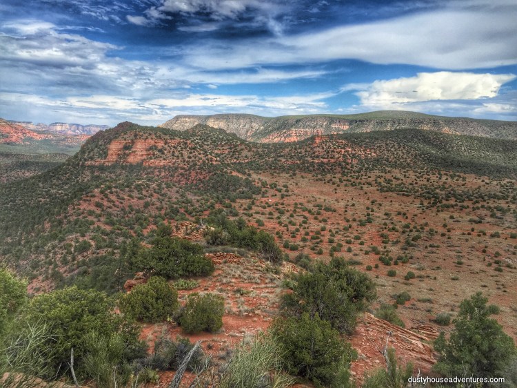
The most fun I’ve been having this year has been indian ruin hunting in central Arizona. I am completely enamored with the region of Sycamore Canyon Wilderness in particular. It is not only astonishingly beautiful (considered to be “the insider’s Grand Canyon”), but also my father grew up with Sycamore Canyon at his backdoor, so trips to the area are especially meaningful to me.
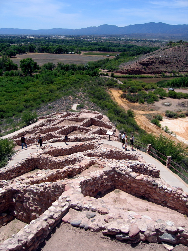
Both Montezuma’s Castle National Monument and Tuzigoot National Monument are adjacent to the Sycamore Canyon Wilderness. They each feature what I call “caged versions” of the hundreds of undisturbed thousand-year-old masonry shelters that are scattered throughout the wilderness, far from the prying eyes and destructive hands of the curious. Montezuma’s Castle is a cliff dwelling built into a natural rock overhang on the side of a cliff. Tuzigoot is a “pueblo” style building that is on flat ground like customary houses. Both are preserved and maintained as outdoor museums by the National Park Service. These monuments are wonderful for those who prefer not to bushwhack around the wilderness on humid 100 degree days to see history in its natural setting, but the reason they are right next to each other is because they were once part of the natural setting and there are many more like them out there, just a few miles away, undisturbed, being part of our American cultural heritage.

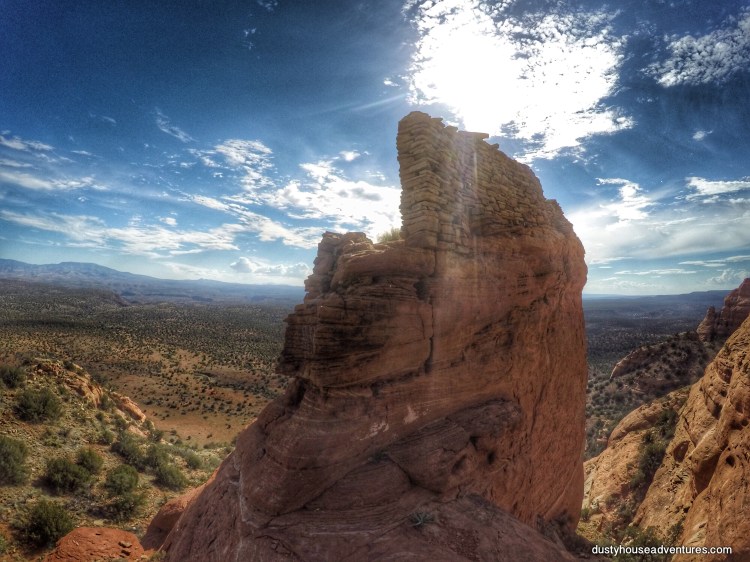
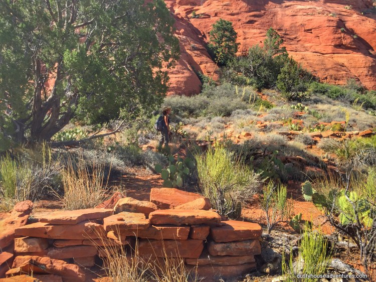
You can find a cliff dwelling almost identical to Montezuma’s Castle, in its natural state of decay (preservation), that has been untouched by restoration, just a few miles away as the crow flies. As the crow flies is the key, it is actually a grueling 3-hour 4wd drive from a paved road plus a 2 mile hike. Or you can do it the hard way and take a 1/2 hour 4wd drive and a strenuous 8 mile hike. I’ve done both, but the hike seems to take less time because the access is more direct. The reward is a cliff dwelling that is called by some “Little Montezuma’s Castle”. (Photos below.)


The three photos above were taken on my previous visit to the canyon in March. To see many more photos of this astonishingly well preserved cliff dwelling in its natural setting see this blog post Over The Cliff With A Stranger. On that trip I got lost in the bushes and ended up stumbling upon a broken metate (grinding rock) just stuck in the mud amongst stones. I also met a local who told me that all I had to do was peck around the side canyons and I would find so much more. I finally got back out there recently and was thrilled at what I found!


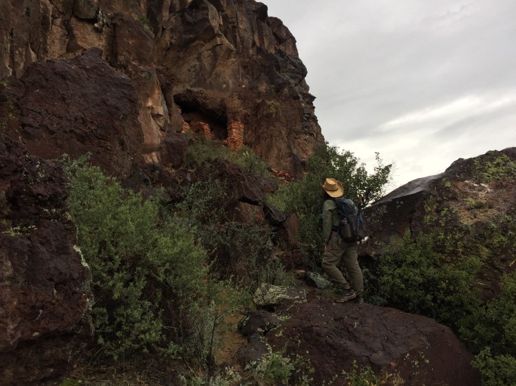
The first day I spent hiking up a nameless wash for cliff dwellings. I had read that cliff dwellings were sometimes built adjacent to natural water sources like seeps — a place where rainwater has gathered in a pocket inside the rock and seeps out like a faucet. How convenient. I spotted a lot of greenery growing out of a crack in the cliff and I became obsessed with it. It took me on a sketchy scramble up the side of the canyon to see if I could find a ruin next to that obvious seep. Two snack breaks into this approach it was concluded that there was no safe way to get all the way up there and the same was probably true of the indians who had the good sense not to live there. As an afternoon storm began to roll in I turned around to assess a wash on the other side of the rise from where I’d come and what did I see? Ruins!
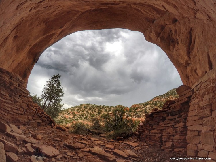
There is nothing like sitting in a prehistoric shelter during a storm to get the sense of what it would be like to live in one. Although most of the protective walls and ceilings were missing, I still felt cozy and protected from the lightning storm outside.
This ruin was fascinating because it seemed to be extremely old. It had about three remaining rooms and judging by the smoke stains on the rocks some had been moved around, probably to fill holes in the masonry.


The black smoke stains or desert varnish on the back wall of the shelter were really odd. They were on an underneath layer. It was as if the naked stone wall had been used for a dwelling, then at a later date stucco had been slicked over the wall when it was “remodelled” by a more recent resident (circa the year 1200), then over hundreds of years that stucco had eroded revealing the original smoke stained wall. Just fascinating and beautiful.
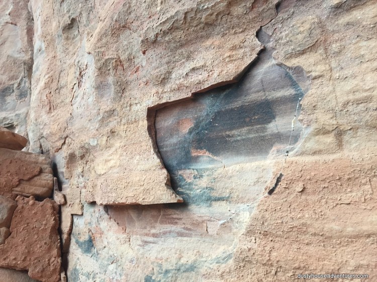
Also on the back wall were pictographs (painted imagery). There were a few that looked like some annoying modern vandal came in with a piece of charcoal and drew some tacky stick horses. I thought they were graffiti and didn’t include them in this post originally, but have since learned about “scratched rock art”, which is a more modern, thinner/finer style of art that is often scratched or painted over older, cruder, images. That is what I think these were. Perhaps the thin-lined images were only 200 years old versus the wider-lined images which may have been 700 years old.


The more crude wider-line images had a patina over them and were consistent with what I’ve learned of the the imagery of petroglyphs in the region so I believed them to be legit. Below is a picture of the natural panel and then I enhanced the color so you can see them better.


I was very excited by these. I think they look like these Hohokam images of quadrupeds in my book “Indian Rock Art Of the Southwest” by Polly Schaafsma.
The next day of exploration was equally exciting. Visible from the plateau was a masonry wall, the only remaining wall of a one-room cliff dwelling, built on top of a spire. The goal was to get to that spire and try to scale the rock to stand in the room.
To my surprise (although I don’t know why I should be surprised) all along the way to the high lookout were the ruins of an Hohokam village. Pottery shards, arrowhead flints, and building ruins lead the way to the lookout on the spire.


Here’s where Tuzigoot comes into it.
This village I visited on the plateau was comprised of pueblo style buildings, not built into cliffs, but on level ground. The pueblos seemed to be typically two or three rooms wide. The remaining walls were only a few feet high. The flat rocks that once shaped the completed buildings lie scattered around the ruins.


Talk about a room with a view!

It required a bit of climbing to reach the lookout on the spire, but I did it.
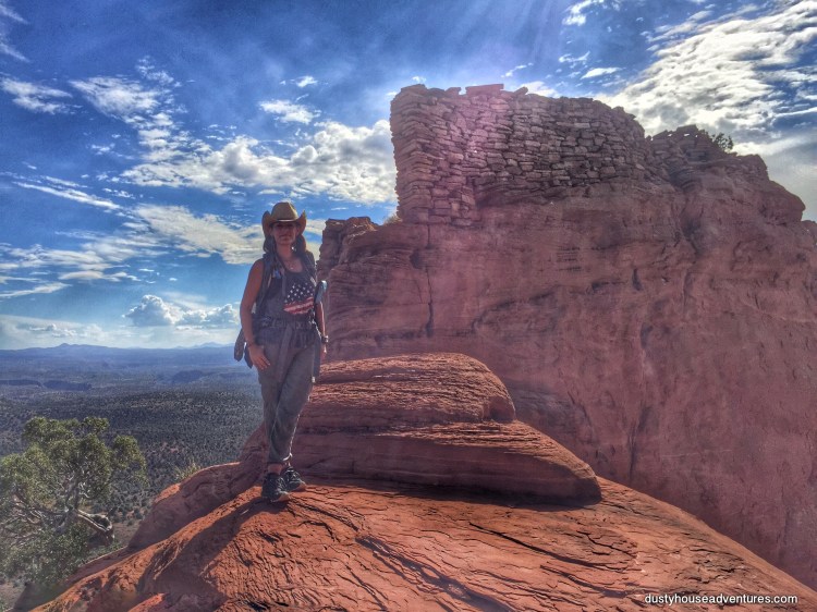
This is as close as I could get to the top. The last little bit was just too steep for me to climb. I may have been able to get up, but I wasn’t confident I could get down. I’m guessing that there has been more erosion to the approach since this building was in use. Either that or they used ladders to get up there.
The drop off was slightly intimidating. This is how high up this thing was.

Here’s the view from up there. One could easily see and be able to signal other outposts miles and miles away.
After this trip I visited with a history teacher friend of mine who recently wrote a book about the natives of the region. He confirmed what I had read, that the Hohokam not only originated as a people from the south bringing their agricultural expertise to the region, but they also traveled south to the Gulf of Mexico and traded there. My friend cautioned me not to get too excited about the first Spanish explorers only reaching Latin America in the 1400s. He said he is confident that there were explorers from more developed nations in the region long before that. He floated the idea that cliff dwellings like “the lookout on the spire” that could have been used to send smoke signals to other outposts could have also signaled using mirrors! What a notion! Once that idea got into my head I realised that trade across the continent from any direction could have brought mirrors. Whether or not you can accept this idea depends on how married you are to the history books you grew up reading.
It has been concluded by examining the region’s rock art that the Hohokam traded for seashells at the Gulf Of Mexico. All inland tribes prized seashells and traded with coastal tribes for them as money. And in fact, I found a seashell on this trek! Yes, it could be a fossil from a time millions of years ago when the entire desert was under the sea, but it is far more likely that the shell on this plateau was actually an item that was procured on a trading trip.

These expeditions are real mindbenders because I see these things while I’m out and they make only a mild impression on me at the time of discovery. Everything at the time is such an assault to the senses that I don’t even have the intellectual or emotional reserve to process everything I see. It is when I return and start to piece together the forensics of the scene that the real amazement of what I’ve seen truly hits me. This is why I take a lot of photos. Document now, be astonished forever.
Oh, but there’s more. The trip was far from finished. I also had to explore down in the belly of the canyon where it was to be so much hotter and equally magnificent.

I know that by now you are feeling pretty ho-hum about pueblos and cliff dwellings. I mean, how many can a person see in one blog post? Well, leave it to the Hohokam of Sycamore Canyon to keep changingthings up.
Taylor Cabin is a one-room ranchers shack located about 7 miles (I somehow managed to turn it into 10 miles) down a nicely maintained trail from “the lookout on the spire”. It is on the National Register of Historic Places and warrants a photo tour of its own, but I’ll put that in another post. It backs up to the hills by the now dry riverbed. I wonder if it was possibly built on the foundations of a pueblo ruin. It has the same construction and just a few yards away from the cabin is a cave with pueblo style walls surrounding it that was obviously used most recently for storage.


But the best part of this site is on the plateau above Taylor Cabin. There are more pueblo ruins and an geoglyph! A geoglyph is a flat piece of art made by placing rocks on the ground to form a shape that is best viewed from above.

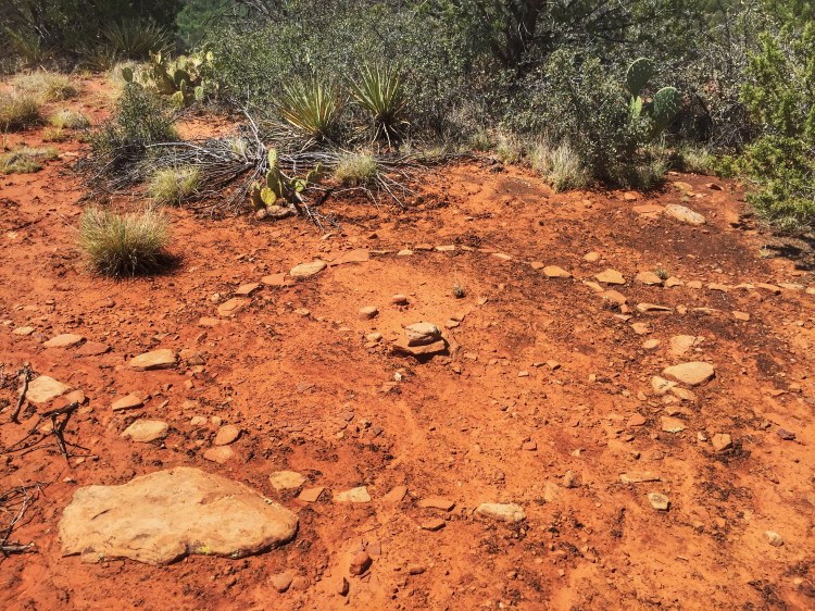
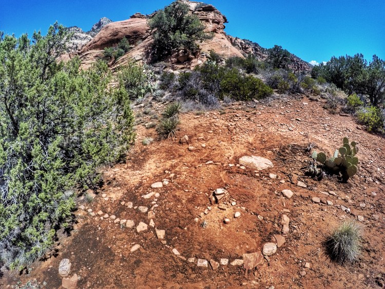
This geoglyph is a circle with a central stone, is intersected into quadrants with four perpendicular lines and has two channels leading off like a spiral. What comes to mind when I see this is a Medicine Wheel which is a stone circle that usually has reference to the four directions and has spiritual significance. I won’t even begin to have the expertise to interpret this geoglyph. All I can say is that I feel lucky to have seen it. Gratitude to the trail god for leading me to it. I hope it is prehistoric as its remote village setting implies.
You can see why this place drives me absolutely crazy, can’t you? I love hidden history in the desert. It is my passion. Not only is Arizona chock full of archaeology from its original residents, but the scenery is colorful, grand and awe inspiring. Also, I deeply appreciate seeing history in its natural context. It is wonderful that places like Montezuma’s Castle and Tuzigoot preserve and interpret archaeology. Education is always good. But to stand in a prehistoric village while smelling the hot earth, take shelter in an ancient home during a storm, hike between village sites through canyons and feel their distance from one another is like time travel. One can live history by actually walking in historic footsteps. This is why I explore human history in the wilderness.
Soon I will be back in Arizona exploring the Ancha region in canyons that are rumored to have two-story tall cliff dwellings with the second floor still in tact. Ahh, swoon. I can’t wait!

After reading your post I feel you do have passion for travelling in both space and time. 65 yrs ago I was born with the same passion. I also believe, because of the amount of self-portraits and the flashy fashions that theirs also a shallower motive involved.
All I ask is that you be careful how much info you put out their. Some of us consider the trail-less solitude to be a big part of the magic. Sincerely, DRR,
Thank you for reading. We all hike our own hikes and leave each other the freedom to do so. Enjoy your journey.
..you were neither over the top with your self imagery or too revealing with the ruin locations..
Not Hohokam, Southern Sinagua
Interesting. Why do you think so? Because you maybe the Hohokam were there so much earlier? Of course, the “Southern Sinagua” appellation is just a modern “white man’s” name for the people. We don’t know what they called themselves. You are sure these ruins were from a whole new wave of people after the Hohokam? Sometimes the same structures were used over and over, remodelled, rebuilt… Please tell me more. Why are the museums and historians attributing Mont. Castle and Tuzigoot and all the nearby aquaducts on the landscape to the Hohokam?
These are attributed to southern sinagua. The style of construction and time period differ from that of tutzigoot… you can tell by looking at the structure but also because “cliff dwellings” are from a time when people had differing needs from those living at the larger exposed pueblos of other time periods. This explains the difference in the locations they’re built. (tutzigoot is on a hilltop not a cliff) Montezumas caste is also attributed to “southern sinagua” though it’s clear it has ancestral Pueblo (anasazi) influences.
Great post and photography! Maybe someday when I am fit enough I’ll book a hike with you (I’ve been going it alone even though I know I shouldn’t). Thank you for sharing 🙂
I appreciate your encouraging words. Thank you.
As a person in search of the history of the 2.01 acres in the Yavapai mountains near Dewey, Az. We, my landmate, chihuahua and myself, have been collecting artifacts on this property for 9yrs. 2 months so far. Through both empathic powers and research, I have collected a few things such as stone axes, arrow heads of several types and styles. On this land there are many things like rocks in the shape of snakes. In fact, the rock snake is everywhere in this area. Beautiful jewelry pieces are just waiting to be mounted and strung. It is my belief that the first people used this area for hosting pow-wows for visitors as far as Oregon, New Mexico, Mexico, California, and Utah. This gathering happened because of Trade of goods. The gatherings brought the shamans and trade of plants and potions. One of the plants is the cliff rose bush. This medicinal plant was used to cure multiple cures including constipation, measles, poxes, reduce inflammation, detoxing, and so much more. Recently, my landmate found an instrument made of antler behind out water tank.
It is remarkably interesting and the journey to you has been educational, baffling, and beautiful. We invite you to tramp around and tell me if you see what I see in the mountain behind us. Ruins. The rock tell a story also of Queens, Conquistadores, and such. However, it is the rock snakes everywhere large and small. I know that the Hopi comes to mind, and I really lean towards that hard. Your thoughts would be awesome. Promise as a historian of Arizona you will not be disappointed. Next trail is the Homol Avi or Homolavi considered to be the ancestors of the Hopi. Gotta love the Great Course’s channel.
On the empathic side of things and what the evidence shows is that this land that is part of the first plateau from the behind peaks. This was where surrounding Nations from not just Arizona but also the four corners, Oregon and probably California. When I say great gathering; I kid you not. One never know what one might find. Even had a chalice from the middle east come from those mountains behind from a flashflood. That really got me onto what’s up there. How about you and I explore it together. It would be fun. Google Wait a Minute Wy, Dewey Arizona. The view is stunning. Yes, that is my streets name.
You have my email. I look forward to hearing from you.
Blessed Be
BaubeeSioux
Hello. Thanks for your note! I would love to see photos of some of the rock snakes to see what you are referring to. Will you email me a pic or 2?
The “Ancestral Pueblo” (Anasazi) people are the ancestors of many groups now in the southwest, including the Hopi.
I don’t know about Pow Wows with people from as far north as Oregon but I do know that there were trade corridors that goods would travel on. It isn’t necessarily the case that people made the full journey, just that goods changed hands up and down travel routes. I’m not saying that Pow Wow gatherings didn’t happen, I’m just saying I don’t know anything about that. Religious pilgrimages, on the other hand, definitely occurred over long distances. The only people I can think of who would have connections that far north and south of the Great Basin are the Paiute. What artifacts have you seen that make you think they come from Oregon?
I’m very curious about those rock snakes. I hope you will let me take a peek at your photos!
Thanks for reaching out. Have a wonderful day.
Angeline